Home › Job codes › Air Force › 1N1X1 Geospatial Intelligence

Air Force 1N1X1 · Geospatial Intelligence

You bring the Geospatial Intelligence language you know. We write your resume in the language hiring managers want to see.

In the Air Force, you spoke a specific language, and it's the one you know. Civilian hiring managers don't speak it. We bridge that gap for you.

Build My Resume $19 one-time · finished in minutes

Geospatial Intelligence Airmen exploit imagery and geospatial data to find, track, and report activity. Civilian employers call that GIS analysis, remote sensing, imagery analysis, and mapping.

  • No account needed
  • 7 professional styles
  • Word + PDF
  • LinkedIn Starter Kit
  • Career Match Report
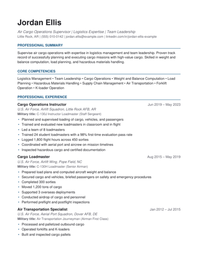
Sample DutyToResume resume in the Modern Professional style
Sample resume (Modern Professional style)

How it works

  1. 1

    Paste your duties

    Copy from your EPRs or just type what you did as a Geospatial Intelligence Airman, plus any real numbers.

  2. 2

    We write it for you

    We translate everything into civilian language and build the whole resume. Nothing invented.

  3. 3

    Download and apply

    Get 7 polished styles in Word and PDF, your LinkedIn Starter Kit (new to LinkedIn?), and your Career Match Report. Ready to send.

Preview of your Career Match Report

Civilian jobs your experience qualifies you for

Your $19 package includes a personal Career Match Report built from your own duties. Here are the jobs the U.S. Department of Labor matches to 1N1X1, with typical national pay.

Geodetic Surveyors

$75,440/yr typical pay

Growing

Geographic Information Systems Technologists and Technicians

$116,580/yr typical pay

Growing

Intelligence Analysts

$93,790/yr typical pay

Stable demand

Surveying and Mapping Technicians

$54,240/yr typical pay

Growing

Remote Sensing Scientists and Technologists

$122,570/yr typical pay

Slow growth

Typical pay = national median from the U.S. Bureau of Labor Statistics. Pay varies by location and experience. Job matches from the O*NET Military Crosswalk.

What employers will see on your resume

Military language confuses civilian recruiters. Here is how we rewrite typical Geospatial Intelligence duties.

BeforeExploited full-motion video for target activity

On your resumeAnalyzed live video and imagery to identify and report activity

BeforeProduced annotated imagery products

On your resumeProduced annotated imagery and map products

BeforeUsed ArcGIS for geospatial analysis

On your resumePerformed geospatial analysis using ArcGIS

BeforeWrote imagery reports under time pressure

On your resumeWrote accurate imagery reports under tight deadlines

Examples only. Your resume is written from your own duties and uses only the numbers you give us.

Build My Resume: $19

Also in your Career Match Report

Keywords we build into your resume automatically

Most employers use resume-screening software (an ATS, or applicant tracking system) that searches for job-related words before a person ever reads your resume. We work the right ones in for you, using only what you actually did. Your report also lists them for your LinkedIn profile.

GISArcGISRemote sensingImagery analysisGeospatial analysisMappingData visualizationReport writingAttention to detailSecurity clearance

Credentials worth exploring next

A note from the founder

I served on active duty in the U.S. Air Force from 2001 to 2009 as a 2W0 Munitions Systems specialist and a C-130 Loadmaster. I didn't work Geospatial Intelligence, so this page leans on O*NET and BLS data rather than my own memories. The problem is the same, though: your experience is valuable, and it has to be written in the civilian employer's language.

Travis Loso, founder of DutyToResume

Questions veterans ask

Do I list my AFSC on a civilian resume?

Lead with a civilian title, such as Geodetic Surveyor, and add a secondary line like 'Military title: Geospatial Intelligence (1N1X1)'. Recruiters search civilian titles; the AFSC helps veteran-friendly employers and federal HR.

What civilian jobs fit 1N1X1 best?

O*NET maps 1N1X1 to 10 related civilian occupations. The closest matches include geodetic surveyors, geographic information systems technologists and technicians, and intelligence analysts.

How many Airmen work in 1N1?

The Air & Space Forces Magazine 2025 Almanac lists 2,128 Total Force enlisted Airmen in 1N1 (Imagery Analysis) as of Sept. 30, 2024, which makes it one of the largest enlisted specialties. That's a lot of veterans competing for the same civilian roles, so a clear translation matters.

Related job codes

Your Geospatial Intelligence experience is worth more than recruiters can tell.

Get a finished, recruiter-ready resume in minutes. $19, one time.

Build My Resume

Last updated 2026-10-13. Sources: O*NET OnLine Military Crosswalk (O*NET 31.0), https://www.onetonline.org/crosswalk/MOC; U.S. Bureau of Labor Statistics 2025 wage data and 2024-2034 employment projections, as published on O*NET OnLine occupation summaries.

1N1X1 Geospatial Intelligence → civilian resumeBuild My Resume